Public cadastral map of the Russian Federation (GAC) is an online platform, which contains information about all objects of real estate of Russia, and recently appeared it 5, of remastered.
Using digital technology, the Federal service for state registration, cadastre and cartography (Rosreestr) has created an online service that facilitated obtaining information about areas and buildings. The first cadastral map was created in 2010.
Since then she has improved. In the updated PAC-5 information about real estate objects and land plots are formed based on relevant information, which enters in the register of Cadastral chamber.
Virtual platform
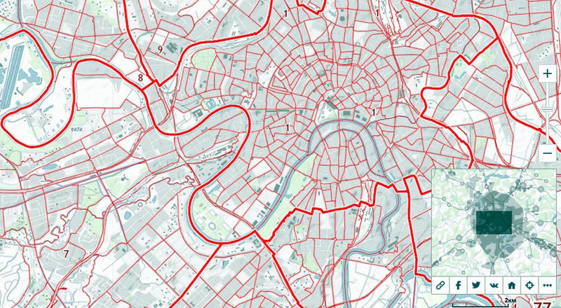
Public cadastral map (PKK) – an official resource of the building displays 50 million objects: sites, structures, buildings, houses. Any of us can find any information he needs about the house, apartment or any other object if it has a cadastral number in the egrn.
To get on the map just: http://pkk5.rosreestr.ru/. Come in and see the map of Russia, which is easily and quickly increased in scale. Choose a city, for example, the Murmansk. Looking out, instantly moving with the mouse. Here it is, the Lenin Avenue. Find the right site. Clicking on it, the pop-up window you can immediately find out its cadastral number and the cadastral number of the quarter as well as the status of the site, address, category of land, form of ownership, area, permitted use and the cadastral value (including the cost per square meter). It is clear not only its location, but also the contours and configuration.
By the way, here you can find out and the Statute of limitations of information available in the GAC, as well as the intensity of user requests to the map.
Sites, buildings, districts
Public cadastral map allows you to find objects of different types: sites, buildings, security areas, border areas and regions.
Look for the object of interest can be, not only moving on the map and increasing it. There are other options of search: the cadastral number, the conditional number, address or name of the object.
On the website you can make online request in Rosreestr to receive information about real property objects for the formation of an extract from the Unified state register of real estate (egrn). And it is now required in many cases, and especially for the confirmation of ownership.
In the extract from the egrn obtained through this online platform will be specified: the owner of the property, the presence or absence of liens, or encumbrances as well as ownership history of the object, cadastral area and the value of the property.
The location of the object and its cadastral address, form of ownership, permitted use, total area, cadastral value of the land and name of the cadastral engineer, the date of registration and changes – all this information is available for free.
And here is an extract from the egrn is for the money. One-time e-statement will cost 100 rubles., but you can subscribe to the package, then the cost per discharge will decrease.
Convenient to use
Use of the PAC is convenient because it offers different options for adding objects. For example, the user is free to add them using the drawing functions and by importing the coordinate description. He has the ability to measure the length of the line and the polygon's area, putting coordinates on the map.
And when he found all that was required, the search results can be added to favorites, create links to them, and share them on social networks (Twitter, Facebook, Vkontakte), send by email, print the selected portion of the map.
In addition, the web application allows the GAC to public services and information from service "Offices and reception". Here you can find a list of the offices and reception of Federal registration service serving the territory to which the chosen property or unit of cadastral division, as well as to clarify the exact name of the units of territorial bodies of Rosreestr and its subordinate institutions, their addresses, telephone numbers, name of Manager.
Also important is the presence of feedback on data quality. An authorized user can report a technical error, to obtain background information. Comments sent to technical support the official website of Rosreestr.
Caution: sites-ersatz
The creation of the Public cadastral map of Rosreestr has significantly simplified the search for the desired data on land plots and other real estate listed in the registry, as well as reduced their search to a few minutes.
This electronic resource has become very popular. They are those associated with real estate at work: lawyers, realtors, surveyors. Very handy when using any of the most common current browsers it is possible to gather the necessary professional information, free of charge.
But not only they are turning to this electronic map. Ordinary people also look down here, when you sell or buy a property, come into a fortune. There are plenty of situations?
The main thing – to use the official website of Rosreestr: http://pkk5.rosreestr.ru/and not sites-the substitutes that offer to pay for the free services and where information can be outdated.
It is IMPORTANT to KNOW if the resource you offer to pay for information, you should immediately be wary. So, you were not there. The only paid service on the website of Rosreestr is the receipt of the statement of the egrn.
By the WAY
Soon settlements throughout the country will be digital orthophotos. What it is, says the Deputy head of Rosreestr Vyacheslav Spirenkov:
Speaking about mapping, we are doing settlements for digital orthophotos 2000-m scale. It will be convenient to navigate, to watch, with houses, to determine the coordinates, to carry out surveying and cadastral works.This scale is well suited for correcting cadastral errors, determine the boundaries of plots of agricultural land, boundaries of municipalities, settlements.
Until 2024 we plan to cover the entire settlements of the Russian Federation such aerial photography. All digital orthophotos will be shipped in a single electronic cartographic base. Creating the public service to provide maps and images will be completed next year. They will be able to use Federal and regional Executive authorities, municipalities, the regions, receiving information corresponding to the state standards. All the created materials will be uploaded on the public cadastral map.
Now we have "pilot" in Krasnodar and the Crimea, to regional authorities to check how this service works, how to connect their GIS system."